API Reference
This page lists all available functions and classes in OGGM. It is a hard work to keep everything up-to-date, so don’t hesitate to let us know (see Get in touch) if something’s missing, or help us (see Contributing to OGGM) to write a better documentation!
Workflow
Tools to set-up and run OGGM.
Read the configuration file containing the run’s parameters. |
|
Set the global logger parameters. |
|
Set the glacier intersection database for OGGM to use. |
|
Deletes the content of the working directory. |
|
Initializes the list of Glacier Directories for this run. |
|
Execute a task on gdirs. |
|
Shortcut function: run all flowline preprocessing tasks. |
|
Shortcut function: run all climate related tasks. |
|
Shortcut function: run all ice thickness inversion tasks. |
|
Shortcut function: run all tasks to merge tributaries to a main glacier |
|
Gather as much statistics as possible about a list of glaciers. |
|
Merge the output of the model runs of several gdirs into one file. |
|
Merge the climate input files in the glacier directories into one file. |
|
Gathers the log output for the selected task(s) |
|
Copies the glacier directories and their content to a new location. |
|
Writes the content of a glacier directory to a tar file. |
|
Merge the directories into 1000 bundles as tar files. |
Troubleshooting
Prints the OGGM version and other system information. |
Input/Output
Returns the path to the desired OGGM-sample-file. |
|
Path to the RGI directory. |
|
Path to the RGI region file. |
|
Get a list of glacier outlines selected from their RGI IDs. |
|
Path to the RGI directory containing the intersect files. |
|
Path to the RGI regional intersect file. |
|
Get a list of glacier intersects selected from their RGI IDs. |
|
Returns a path to the desired CRU baseline climate file. |
|
Returns a path to the desired HISTALP baseline climate file. |
|
Get the list of glaciers we have valid mass balance measurements for. |
Entity tasks
Entity tasks are tasks which are applied on single glaciers individually and do not require information from other glaciers (this encompasses the majority of OGGM’s tasks). They are parallelizable.
Very first task: define the glacier’s local grid. |
|
Makes a gridded mask of the glacier outlines and topography. |
|
Compute the centerlines following Kienholz et al., (2014). |
|
Computes more physical Inversion Flowlines from geometrical Centerlines |
|
Computes the Flowline along the unglaciated downstream topography |
|
The bedshape obtained by fitting a parabola to the line’s normals. |
|
Compute the catchment areas of each tributary line. |
|
Computes the intersections between the catchments. |
|
Compute geometrical catchment widths for each point of the flowlines. |
|
Corrects for NaNs and inconsistencies in the geometrical widths. |
|
Processes and writes the CRU baseline climate data for this glacier. |
|
Processes and writes the HISTALP baseline climate data for this glacier. |
|
Processes and writes the climate data from a user-defined climate file. |
|
Applies the anomaly method to GCM climate data |
|
Processes and writes CESM climate data for this glacier. |
|
Read, process and store the CMIP5 climate data data for this glacier. |
|
Compute the local t* and associated glacier-wide mu*. |
|
Compute the flowlines’ mu* and the associated apparent mass-balance. |
|
Compute apparent mb from a linear mass-balance assumption (for testing). |
|
Computes the mu candidates, glacier wide. |
|
Prepares the data needed for the inversion. |
|
Compute the glacier thickness along the flowlines |
|
Filters the last few grid point whilst conserving total volume. |
|
Compute a thickness map by redistributing mass along altitudinal bands. |
|
Compute a thickness map by interpolating between centerlines and border. |
|
Merges data from preprocessing tasks. |
|
Runs the random mass-balance model for a given number of years. |
|
Runs the constant mass-balance model for a given number of years. |
|
Runs a glacier with climate input from e.g. |
Global tasks
Global tasks are tasks which are run on a set of glaciers (most often: all glaciers in the current run). They are not parallelizable at the user level but might use multiprocessing internally.
Detects the best t* for the reference glaciers and writes them to disk |
|
Gather as much statistics as possible about a list of glaciers. |
|
Merge the output of the model runs of several gdirs into one file. |
|
Merge the climate input files in the glacier directories into one file. |
|
Gathers the log output for the selected task(s) |
Classes
Listed here are the classes which are relevant at the API level (i.e. classes which are used and re-used across modules and tasks).
Organizes read and write access to the glacier’s files. |
|
A Centerline has geometrical and flow rooting properties. |
|
The is the input flowline for the model. |
Glacier directories
Glacier directories (see also: GlacierDirectory) are folders
on disk which store the input and output data for a single glacier during
an OGGM run. The data are on disk to be persistent, i.e. they won’t be deleted
unless you ask OGGM to. You can start a run from an existing directory,
avoiding to re-do unnecessary computations.
Initialising a glacier directory
The easiest way to initialize a glacier directory is to start from a pre-processed state available on the OGGM servers:
In [1]: import os

In [2]: import oggm

In [3]: from oggm import cfg, workflow

In [4]: from oggm.utils import gettempdir

In [5]: cfg.initialize()  # always initialize before an OGGM task

# The working directory is where OGGM will store the run's data
In [6]: cfg.PATHS['working_dir'] = os.path.join(gettempdir(), 'Docs_GlacierDir')

In [7]: gdirs = workflow.init_glacier_regions('RGI60-11.00897', from_prepro_level=1,
   ...:                                       prepro_border=10)
   ...:

In [8]: gdir = gdirs[0]  # init_glacier_regions always returns a list
We just downloaded the minimal input for a glacier directory. The
GlacierDirectory object contains the glacier metadata:
In [9]: gdir
Out[9]:
<oggm.GlacierDirectory>
RGI id: RGI60-11.00897
Region: 11: Central Europe
Subregion: 11-01: Alps
Name: Hintereisferner
Glacier type: Glacier
Terminus type: Land-terminating
Area: 8.036 km2
Lon, Lat: (10.7584, 46.8003)
Grid (nx, ny): (139, 94)
Grid (dx, dy): (50.0, -50.0)
In [10]: gdir.rgi_id
�����������������������������������������������������������������������������������������������������������������������������������������������������������������������������������������������������������������������������������������������������������������������������������������������������������������������������������������Out[10]: 'RGI60-11.00897'
It also points to a specific directory in disk, where the files are written to:
In [11]: gdir.dir
Out[11]: '/tmp/OGGM/Docs_GlacierDir/per_glacier/RGI60-11/RGI60-11.00/RGI60-11.00897'
In [12]: os.listdir(gdir.dir)
�������������������������������������������������������������������������������������Out[12]:
['dem.tif',
'diagnostics.json',
'dem_source.txt',
'glacier_grid.json',
'outlines.tar.gz.properties',
'outlines.tar.gz',
'intersects.tar.gz',
'log.txt']
Users usually don’t have to care about where the data is located.
GlacierDirectory objects help you to get this information:
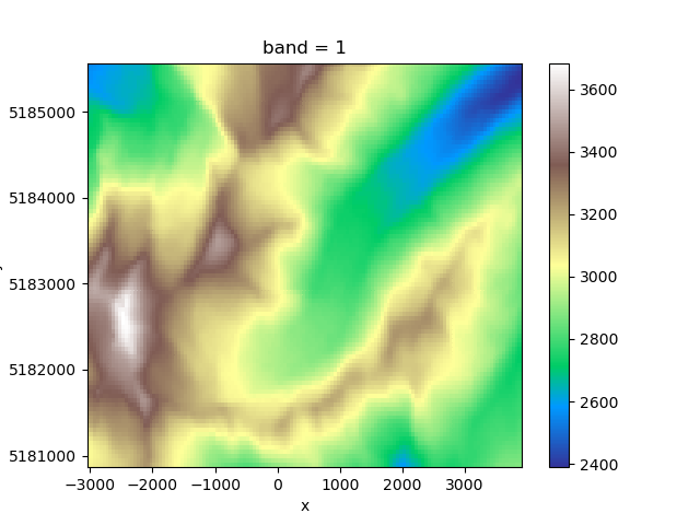
In [13]: fdem = gdir.get_filepath('dem')

In [14]: fdem
Out[14]: '/tmp/OGGM/Docs_GlacierDir/per_glacier/RGI60-11/RGI60-11.00/RGI60-11.00897/dem.tif'

In [15]: import xarray as xr

In [16]: xr.open_rasterio(fdem).plot(cmap='terrain')
Out[16]: <matplotlib.collections.QuadMesh at 0x7f74d2a70588>
This persistence on disk allows for example to continue a workflow that has been previously interrupted. Initialising a GlacierDirectory from a non-empty folder won’t erase its content:
In [17]: gdir = oggm.GlacierDirectory('RGI60-11.00897')

In [18]: os.listdir(gdir.dir)  # the directory still contains the data
Out[18]:
['dem.tif',
 'diagnostics.json',
 'dem_source.txt',
 'glacier_grid.json',
 'outlines.tar.gz.properties',
 'outlines.tar.gz',
 'intersects.tar.gz',
 'log.txt']
cfg.BASENAMES
This is a list of the files that can be found in the glacier directory or
its divides. These data files and their names are standardized and listed in the
oggm.cfg module. If you want to implement your own task you’ll
have to add an entry to this file too.
- calving_loop.csv
A csv file containing the output of each iteration of the find_inversion_calving task loop.
- calving_output.pkl
Calving output (deprecated).
- catchments_intersects.shp
The intersections between cathments (shapefile) in the local map projection (Transverse Mercator).
- centerlines.pkl
A list of
oggm.Centerlineinstances, sorted by flow order.- climate_info.pkl
Some information (dictionary) about the climate data and the mass balance parameters for this glacier.
- climate_monthly.nc
The monthly climate timeseries stored in a netCDF file.
- dem.tif
A geotiff file containing the DEM (reprojected into the local grid).This DEM is not smoothed or gap filles, and is the closest to the original DEM source.
- dem_source.txt
A text file with the source of the topo file (GIMP, SRTM, …).
- diagnostics.json
A dictionary containing runtime diagnostics useful for debugging.
- downstream_line.pkl
A dictionary containing the downsteam line geometry as well as the bed shape computed from a parabolic fit.
- flowline_catchments.shp
Each flowline has a catchment area computed from flow routing algorithms: this shapefile stores the catchment outlines (in the local map projection (Transverse Mercator).
- gcm_data.nc
The monthly GCM climate timeseries stored in a netCDF file.
- geometries.pkl
A dictionary containing the shapely.Polygons of a glacier. The “polygon_hr” entry contains the geometry transformed to the local grid in (i, j) coordinates, while the “polygon_pix” entry contains the geometries transformed into the coarse grid (the i, j elements are integers). The “polygon_area” entry contains the area of the polygon as computed by Shapely. The “catchment_indices” entrycontains a list of len n_centerlines, each element containing a numpy array of the indices in the glacier grid which represent the centerlines catchment area.
- glacier_grid.json
A
salem.Gridhandling the georeferencing of the local grid.- gridded_data.nc
A netcdf file containing several gridded data variables such as topography, the glacier masks, the interpolated 2D glacier bed, and more.
- hypsometry.csv
A hypsometry file computed by OGGM and provided in the same format as the RGI (useful for diagnostics).
- intersects.shp
The glacier intersects in the local map projection (Transverse Mercator).
- inversion_flowlines.pkl
A “better” version of the Centerlines, now on a regular spacing i.e., not on the gridded (i, j) indices. The tails of the tributaries are cut out to make more realistic junctions. They are now “1.5D” i.e., with a width.
- inversion_input.pkl
List of dicts containing the data needed for the inversion.
- inversion_output.pkl
List of dicts containing the output data from the inversion.
- inversion_params.pkl
Dict of fs and fd as computed by the inversion optimisation.
- linear_mb_params.pkl
When using a linear mass-balance for the inversion, this dict stores the optimal ela_h and grad.
- local_mustar.json
A dict containing the glacier’s t*, bias, and the flowlines’ mu*
- model_diagnostics.nc
A netcdf file containing the model diagnostics (volume, mass-balance, length…).
- model_flowlines.pkl
List of flowlines ready to be run by the model.
- model_run.nc
A netcdf file containing enough information to reconstruct the entire flowline glacier along the run (can be data expensive).
- outlines.shp
The glacier outlines in the local map projection (Transverse Mercator).
Mass-balance
Mass-balance models found in the core.massbalance module.
They follow the MassBalanceModel() interface. Here is a quick summary
of the units and conventions used by all models:
Units
The computed mass-balance is in units of [m ice s-1] (“meters of ice per
second”), unless otherwise specified (e.g. for the utility function
get_specific_mb).
The conversion from the climatic mass-balance ([kg m-2 s-1] ) therefore assumes
an ice density given by cfg.PARAMS['ice_density'] (currently: 900 kg m-3).
Time
The time system used by OGGM is a simple “fraction of year” system, where the floating year can be used for conversion to months and years:
In [19]: from oggm.utils import floatyear_to_date, date_to_floatyear
In [20]: date_to_floatyear(1982, 12)
Out[20]: 1982.9166666666667
In [21]: floatyear_to_date(1.2)
����������������������������Out[21]: (1, 3)
Interface
Common logic for the mass balance models. |
|
Monthly mass-balance at given altitude(s) for a moment in time. |
|
Like self.get_monthly_mb(), but for annual MB. |
|
Specific mb for this year and a specific glacier geometry. |
|
Compute the equilibrium line altitude for this year |
Models
Constant mass-balance as a linear function of altitude. |
|
Mass balance during the climate data period. |
|
Constant mass-balance during a chosen period. |
|
Random shuffle of all MB years within a given time period. |
|
Adding uncertainty to a mass balance model. |
|
Handle mass-balance at the glacier level instead of flowline level. |